Current Research Projects
Research Topics, Funding Agency and Total Grant:
[3] Demonstration application of seismic anomaly monitoring technology based on earthquake gestation process (PI, 2020–2023)
- National Key Research and Development Program of China (No. 2019YFC1509205)
- ¥490,000
[2] On the use of optical, seismic and geodetic data for the study of coseismic deformation and source parameters of two large strike slip events in Tibet (PI, 2019–2021)
- National Natural Science Foundation of China, NSFC (No. 41804015)
- ¥240,000
[1] Improved fault-slip source model for the 2001 Mw 7.8 Kokoxili earthquake in Tibet from the combination analysis of satellite radar data, optical imagery and seismic data (PI, 2016–2019)
- Research Grants Council (RGC) of Hong Kong, Early Career Scheme (No. F-PP4B)
- HK$670,000
Previous Research Projects
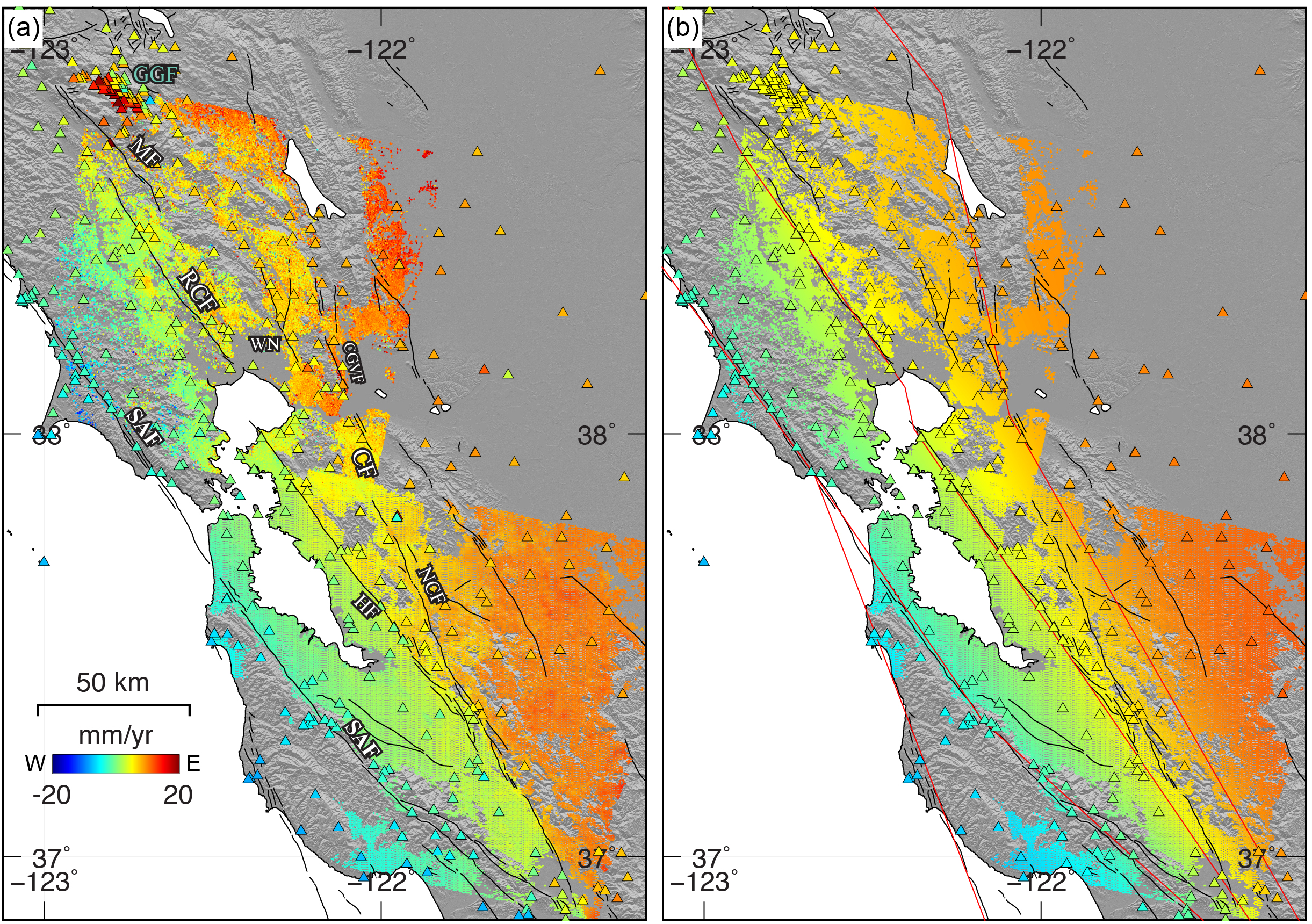
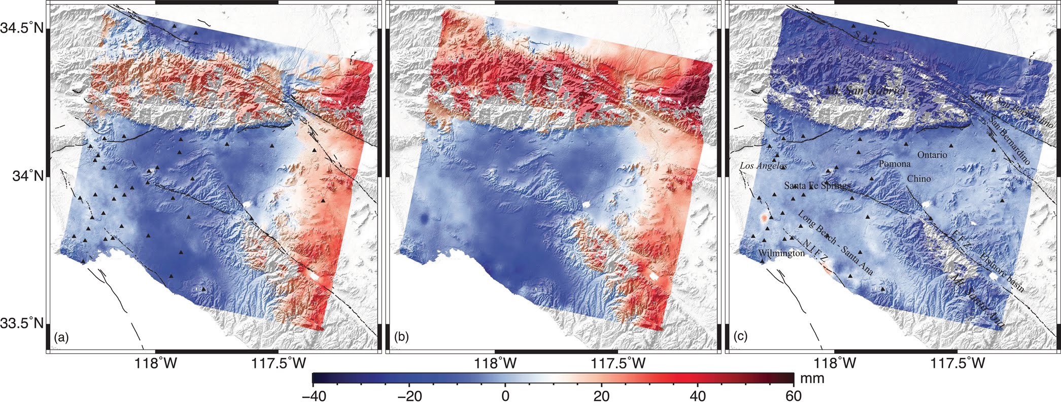
Interseismic Ground Deformation and Fault Slip Rates in the Greater San Francisco Bay Area From Two Decades of Space Geodetic Data (Xu et al., J. Geophys. Res., 2018a)
The detailed spatial variations of strain accumulation and creep on major faults in the northern San Francisco Bay Area, which are important for seismic potential and evaluation of natural hazards, remain poorly understood. We combined two decades of interferometric synthetic aperture radar data with GPS data to obtain a high spatial and temporal coverage of ground deformation. We found surface creep along the central section of the Rodgers Creek fault and along the Concord fault. No surface creep is geodetically resolved along the West Napa and Green Valley fault zones.
联合大地测量研究断层蠕滑
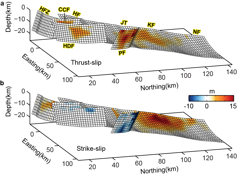
Transpressional Rupture Cascade of the 2016 Mw 7.8 Kaikoura Earthquake, New Zealand (Xu et al., J. Geophys. Res., 2018b)
Large earthquakes often do not occur on a simple planar fault but involve rupture of multiple geometrically complex faults. We combine space geodesy and seismology techniques to study subsurface fault geometry, slip distribution, and the kinematics of the 2016 Kaikoura earthquake. Our results shed important light on the study of earthquakes and seismic hazard evaluation in geometrically complex fault systems.
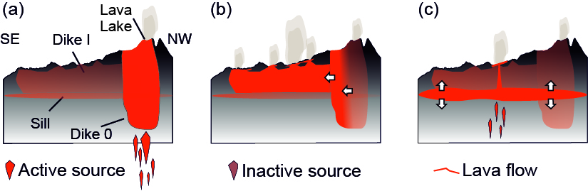
Magmatic architecture within a rift segment: Articulate axial magma storage at Erta Ale volcano, Ethiopia (Xu et al., Earth Planet. Sci. Lett., 2017)
Understanding the magmatic systems beneath rift volcanoes provides insights into the deeper processes associated with rift architecture and development. We combine high-resolution satellite optical imagery and radar interferometry (InSAR) to infer the shape, location and orientation of the conduits feeding the 2017 Erta Ale eruption. Our results may provide new constraints on the organization of magma plumbing systems beneath volcanoes in continental and marine settings.
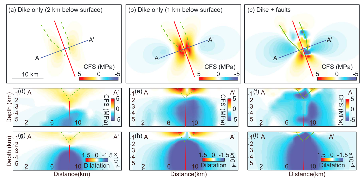
Dike-Fault Interactions during the 2009 Harrat Lunayyir Dike Intrusion (Xu et al., J. Geophys. Res., 2016)
The northwester Saudi Arabia was regarded as seismically quite region, but between April and June 2009 a swarm of more than 30000 earthquakes with a peak Mw 5.7 shock on May 19, took place in at the Harrat Lunayyir, one of the lava fields in the province. We used a series of Envisat data in wide swath mode to study the deformation precursory to the 2009 Harrat Lunayyir dike intrusion as well as ground deforamtion during post-diking period.
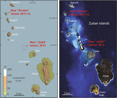
The 2011-12 and 2013 Jebel Zubair Surtseyan Volcanic Eruptions in the southern Red Sea (Xu et al., Nat. Comm., 2015)
Two Surtseyan eruptions occurred within Zubair archipelago in 2012-11 and 2013. Both eruptions started on the sea floor and resulted in a formation of new islands. We studied the 2011-12 and 2013 Jebel Zubair volcanic eruptions with high-resolution radar and optical satellite remote sensing. These events occurred contemporaneously with several local earthquake swarms of the type that typically accompany magma intrusions. Earthquake activity has been affecting the southern Red Sea for decades, suggesting the presence of a magmatically active zone that has previously escaped notice..
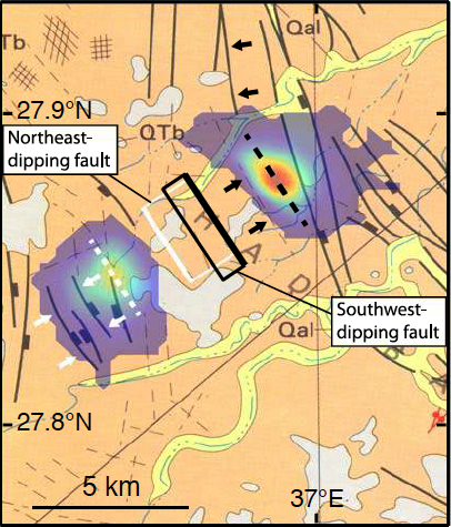
Identifying Active Faults by Improving Earthquake Locations with InSAR Data and Bayesian Estimation: The 2004 Tabuk (Saudi Arabia) Earthquake Sequence(Xu et al., Bull. Seismol. Soc. Am. 2015)
A sequence of shallow earthquakes took place on the eastern flank of the Red Sea rift in 2004 . The earthquakes could not be well located, making it difficult to associate the activity with one of the many mapped faults in the area and thus to improve the assessment of seismic hazard in the region. We used interferometric synthetic aperture radar data to improve the location and source parameters of the largest event of this sequence. The results demonstrate InSAR can be used to improve locations of moderately sized earthquakes and thus to identify faults that are currently active.
Correcting atmospheric effects on InSAR with MERIS water vapor data and elevation-dependent interpolation model (Xu et al., Chinese J. Geophys. 2010; Xu et al., J. Geod., 2011; Li et al., Geophys. J. Int, 2012)
Funding sources